The Buckingham Canal
From Ennore to Mahabalipuram, fifty metres at a time
Built 1806-1882 to carry salt, firewood and dried fish into Madras, the Buckingham Canal today is Chennai's flood carrier and the spine of the city's eastern waterways: 74.5 km, measured here end to end, fifty metres at a time.
Today on the canal
Sentinel-2 window 1 Jun - 18 Aug 2026 (clearest-pixel composites)Ten-metre pixels read narrow city reaches conservatively; the ribbon shows surface condition, not flow. Suspended-sediment readings cover the reaches with enough open water; depth needs a boat, and the last public depth survey is from 2014.
The industrial mouth
Regulation has steadily moved industry's routine discharges off the canal; what remains to manage is the city's sewage and the storm-season event. Continuous measurement is how the next question gets answered in hours.
The canal enters Chennai through its heaviest industry: two power stations, a refinery belt, a port. The consent regime has steadily moved routine industrial discharge off the canal, and TNPCB's investigation of the August 2026 fish kill is under way. Continuous measurement alongside the regulator's is how such questions get answered quickly.
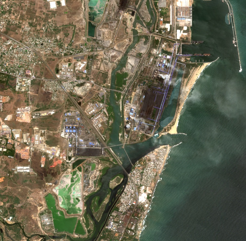 Sentinel-2 · Jun–Aug 2026
▸The receipts (5)
- Fly-ash silting about 1 m deep on the 2.5 km NCTPS-Kamarajar stretch; WRD dredging of ~4.30 lakh cubic metres began mid-2020 under NGT direction, funded by a Rs 28.5 crore Tangedco deposit plus Rs 66.23 lakh for the North Buckingham Canal.
- A mass fish kill hit this reach 15-17 Aug 2026 (~6-7 km, Kattukuppam to Kolivakkam): tonnes of mullet, ladyfish, croakers, prawns and crabs. Fishers blocked the Ennore expressway. TNPCB lab results were pending as of 18 Aug 2026.
- Ash slurry pipelines cross the canal en route to the NCTPS ash pond; reporting found spots where canal flow is completely dead nearest the plant, with low tide exposing thick ash-silt deposits.
- On current consents, NCTPS Stages I and II are permitted to discharge 2.38 and 4.90 million KLD of cooling water respectively into the Ennore creek system - the largest consented discharges there.
- On TNPCB's consent books (latest orders 2021-2026), no Manali process industry may discharge effluent to the canal: CPCL is reuse-only (with a consented monsoon stormwater route to the canal, monitored by online sensors and booms), Indian Additives and Ashok Leyland are zero-liquid-discharge, TPL discharges to sea.
The city squeeze
Between the Cooum and the Adyar, survey records give the canal 42 to 143 metres; today's water measures 9.3 m at the narrowest. Restoration mathematics starts from the measured number, and this page carries it every 200 metres.
Through the city the canal runs under the MRTS railway, routed along it in the 1980s after a Planning Commission working group found no other corridor economically available. The reach now holds the alignment's narrowest water, and therefore the clearest case for the measured baseline that restoration planning needs.
▸The width ledger, road by road (14 stretches)
The Cooum-Adyar link, road by road. 'Recorded in the survey era' is the canal's width in the original survey records - the full recorded extent, banks included, so it reads as the canal's entitlement, not just open water. 'Found in ~2012' is what the HSCTC feasibility study measured on the ground; 'Measured 2026' is our transect measurement of today's water surface. In every column the two numbers are the minimum and maximum along that stretch. A dash means we would rather show nothing than an uncertain join.
| Stretch | Recorded in the survey era (m) | Found in ~2012 (m) | Measured 2026 (m) |
|---|---|---|---|
| Adyar River - Greenways Road | 107–116 | 25–31 | 12–21 |
| Greenways Road - Kamaraj Salai | 115–123 | 25–33 | – |
| Kamaraj Salai - Venkatakrishna Road | 98–123 | 33–48 | – |
| Venkatakrishna Road - St. Mary's Road | 122–123 | 37–38 | – |
| St. Mary's Road - Agraharam Road | 133–143 | 28–38 | 16–20 |
| Agraharam Road - Kutchery Road | 113–117 | 33–37 | 14–25 |
| Kutchery Road - P.V. Koil Street | 114–134 | 34–39 | – |
| P.V. Koil Street - Radhakrishna Street | 117–133 | 25–38 | – |
| Radhakrishna Street - Avvai Shanmugam Salai | 120–122 | 30–32 | – |
| Avvai Shanmugam Salai - Besant Road | 100–109 | 25–34 | – |
| Besant Road - Barathi Salai | 89–110 | 24–25 | 16 |
| Barathi Salai - Wallaja Road | 80–111 | 30–36 | – |
| Wallaja Road - Swami Sivanandha Salai | 42–73 | 32–36 | – |
| Swami Sivanandha Salai - Cooum River | 80–93 | 25–28 | 9–195 |
2026 measurements: Neer Vazhvu transects at 50 m spacing from OpenStreetMap water polygons; across all these reaches the median is 18 m with a 6.5 m minimum.
▸The receipts (5)
- Otteri Nullah (38.4 sq km catchment) and the Captain Cotton Canal join the Buckingham Canal at Basin Bridge.
- CPCB's Captain Cotton Canal station recorded dissolved oxygen as low as 0.3 mg/L and BOD up to 120 mg/L in 2024.
- The North Canal joins the Cooum's north bank at the same level behind Chennai Central; there is no continuous canal channel through the junction.
- TNPCB sampling reported in Feb 2025 found the canal's salinity maxima near Napier Bridge (TDS 5,560 mg/L; chloride and sulphate together 2,599 mg/L): the tidal signature of the Cooum mouth.
- The South Buckingham Canal is a tidal canal taking off from the Cooum and running 110 km to Kovalam North lock near Marakkanam, with seven sea openings, lock-controlled, whose sand bars keep them closed about seven months a year.
The marsh's only drain
Everything South Chennai drains passes through one 2.8 km channel into the canal. It is the system's most sensitive point: weather, works and weeds all register here first, which is why it rewards the closest watch.
South Chennai drains through one channel into this canal; the marsh behind it breathes with the tide through the same gate. CMRL has invested in widening the water opening at this crossing, and 2026 field reports tracked a construction-phase narrowing alongside - the kind of change a live baseline registers as it happens.
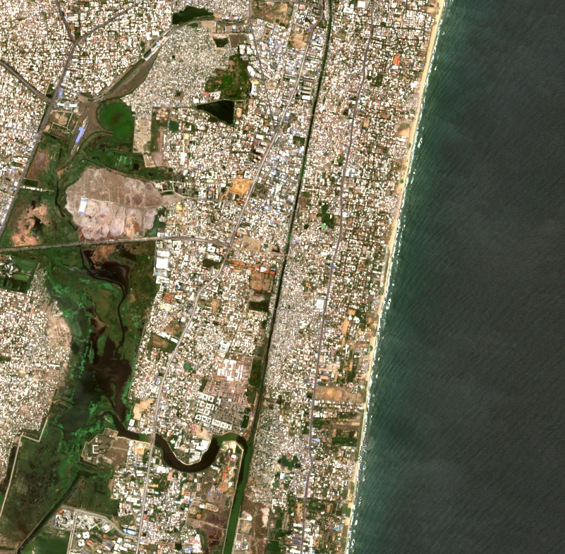 Sentinel-2 · Jun–Aug 2026
▸The receipts (2)
- Okkiyam Maduvu, a 2.8 km channel, is the sole outlet of the ~250 sq km Pallikaranai drainage (65 wetlands) into the canal, and the marsh's only brackish link to the sea at Muttukadu.
- Metro Phase 2 viaduct works narrowed the channel under the OMR bridge from a pre-construction 83.73 m to under 10 m (field observations from 6 May 2026); a second narrowing sat at the Perumbakkam outlet; both sites fall inside the notified Ramsar boundary, within the crossing CMRL's widening programme serves.
The living estuary
Where the tide still reaches, the canal still lives: 126 bird species, working fishers, a boat house - behind a sand bar that closes seven months a year.
Below the city the canal widens into backwaters the tide still reaches, and everything changes: birds in the dozens of species, working fishers, a boat house, brackish water that stays naturally clear of hyacinth. The system hangs on mouths that sand closes for most of the year, and mouth management already has a budget line.
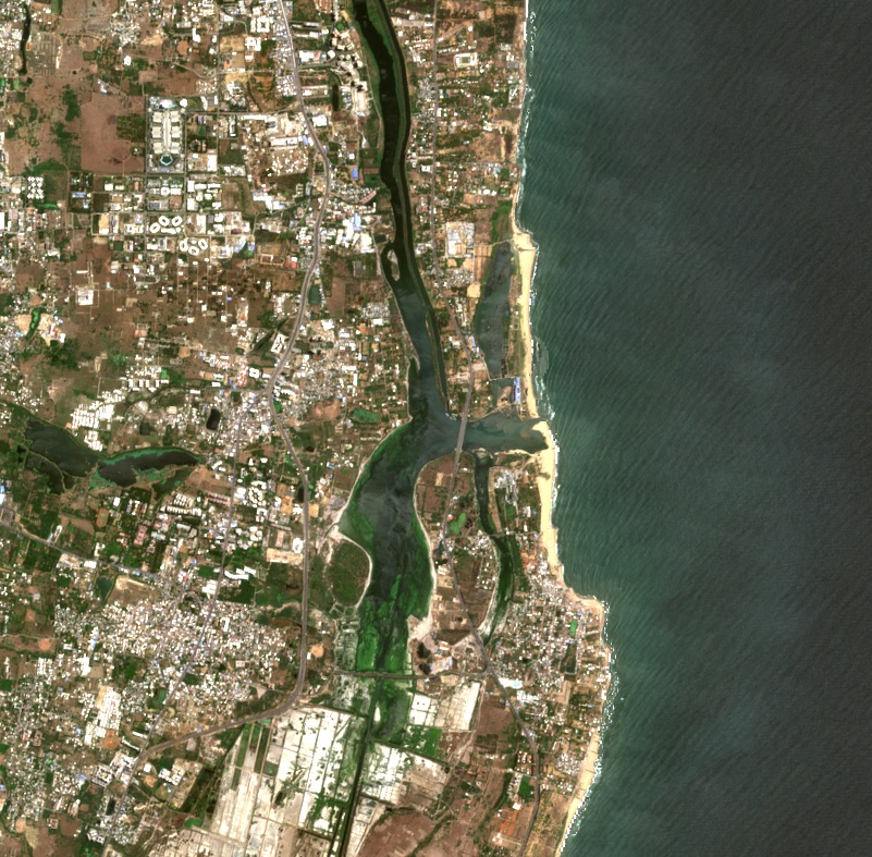 Sentinel-2 · Jun–Aug 2026
▸The receipts (4)
- The Uthandi straight-cut flood escape channel (Rs 91 crore, 550 cusecs capacity against the canal's 3,500) was tendered 8 Jul 2025 and began work in Aug 2025 amid CRZ objections and fisher protests; work has been suspended since Oct 2025 pending NGT proceedings. Water tests en route had found faecal coliform 1,600 MPN/100ml and BOD 26.5 mg/L.
- The Muthukadu Boat House Lock, one of three abandoned navigation locks on the southern canal, stands at 12.8073 N 80.2414 E.
- Muttukadu is a temporarily open/closed estuary: longshore drift closes the mouth roughly March-September; the monsoon reopens it; the mouth varies from a few metres to ~200 m. Water quality deteriorates sharply when closed, with recorded hypoxia fish kills.
- 126 bird species are on the live eBird list for Muttukadu Backwaters (captured 18 Aug 2026), corroborating the 2024 journal survey's 124 species (Jul 2021-Mar 2023 fieldwork, 7 near-threatened).
The intact ribbon
South of Kovalam the canal is quiet and un-encroached: eleven structure-free kilometres, running green with vegetation - the easiest stretch of the alignment to restore.
The last stretch is the canal at its most complete: banks un-encroached (though unprotected), no structures for eleven kilometres, a channel running green with vegetation. It is the least altered water on the alignment, and the easiest place to begin the restoration the current programmes plan.
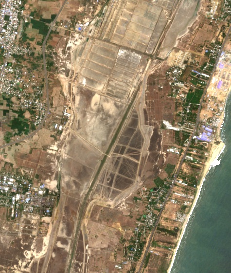 Sentinel-2 · Jun–Aug 2026
▸The receipts (5)
- The Kovalam-Nemmeli 'Great Salt Lake' (~5,000 acres) is a hand-fishery and shorebird wetland fed twice daily by tides through the Muttukadu and Kokilamedu inlets; the canal carries catchment surplus through it.
- The proposed Mamallan reservoir would convert the wetland for 170 MLD of city supply; the project EIA itself recorded 102 bird species, and 22 scientists wrote to the Chief Minister warning of irreversible damage.
- Our satellite screening shows this reach as a continuous vegetated channel with almost no open water at 10 m resolution (corridor vegetation 0.55-0.61, water near zero) - see the km 64-66 chip.
- IWAI's survey found the southern canal's banks unprotected up to the Mahabalipuram Road Bridge, with depths of 0.3-1.3 m.
- IWAI's 2014 scheme placed a proposed Mahabalipuram terminal at 12.6169 N 80.1868 E; the Rs 123.40 crore Thiruvanmiyur-Kalpakkam development stalled with ~Rs 4 crore spent.
The investment runway
Since 2008 the canal has gathered a national-waterway designation, a High Court restoration mandate, audits and sanctions - and in 2026, the largest funding window in its history. The intent is aligned; this page is the baseline to build on.
The canal's record shows sustained intent: a national-waterway designation, a High Court mandate, detailed project reports, an umbrella sanction for the three waterways, and now the Urban Challenge Fund window with a water-metro study in procurement. Seventeen years of groundwork have come together; below is that record, dated and sourced.
- 2008standing
Canal declared part of National Waterway 4
- 2009-10Rs 633.03 cr (widening) + Rs 131.90 cr (two-work sanction)completed in part
JNNURM macro-drainage sanction incl. canal widening and a short-cut diversion channel
- 2014Rs 123.40 crnot completed
Diversion channel discontinued after Rs 90.34 cr of works; IWAI's Rs 123.40 cr Thiruvanmiyur-Kalpakkam scheme launched (~Rs 4 cr of works recorded)
- 2015recorded
The December flood: 12,500 cusecs forced into a 9,000-cusec reach; Velachery inundated
- 2019-20recorded
CAG quantifies 242.73 MLD of raw sewage entering CMA water bodies incl. the canal (CMWSSB estimate, Apr 2019)
- 2020Rs 1,281.88 crsanctioned
Umbrella sanction for the canal, its associated drains and the Adyar and Cooum major drains: G.O.(D) No.419, MAWS, 3 Dec 2020; Rs 408.08 crore of it for the canal (Ennore to Muttukadu, 48 km) and Rs 1,014.28 crore allocated to WRD for 35 works
- 2020-21Rs 1,714 cr + Rs 3,220 crongoing
KfW Kovalam-basin and ADB Kosasthalaiyar-basin drainage programmes (outfalls to the canal system)
- 2022order standing
Madras HC orders demarcation in 6 months, encroachment removal in 1 year, IWAI custody; MRTS pillars exempted; sewage mitigation plan ordered
- 2023Rs 1,696.5 crset aside; successor proposal 2025
WRD restoration DPR submitted (Anna University DGPS survey)
- 2024-25Rs 1,014.28 cr (WRD allocation)under review
Of the 35 WRD works under the Rs 1,281.88 crore sanction, 30 commenced; after the December 2023 floods and the Advisory Committee on Flood Risk in Chennai Metro, the detailed project reports were taken up for review and the works held, with five works (Rs 160.73 crore) untendered pending resettlement; rehabilitation of four canals confluencing in the Buckingham Canal (Rs 120.44 crore) is in progress
- 2025Rs 60.79 crsanctioned
Rs 60.79 crore of the comprehensive restoration works under the Rs 1,281.88 crore sanction moves from Chennai Rivers Restoration Trust funds to State funds
- 2025Rs 91 cr + Rs 2,388 cr (proposal) + Rs 31 crin motion
Uthandi straight-cut tendered (550 cusecs; Jul 2025; work suspended Oct 2025; NGT (SZ) suo motu order of 17 Sep 2025 directing agency affidavits, with CMWSSB's January 2026 report recording the sewage discharges); PWD proposes full-canal restoration to the Centre; Rs 31 cr Chepauk-Greenways starter with IWAI; water-metro feasibility begins
- 2026Rs 7,500 cr (reported)window open
Urban Challenge Fund phase-1 in-principle approval for Cooum-Adyar-Buckingham restoration reported at Rs 7,500 crore (Times of India via Swarajya; no official project list published as of 20 Aug 2026); CMRL floats the Water Metro DFR-cum-DPR tender for Ennore-Mahabalipuram (NIT 13 Aug; bids close 18 Sep 2026)
The measurement layer
Rs 1,281.88 crore stands sanctioned across these waterways, an Urban Challenge Fund approval is reported at Rs 7,500 crore, and the Water Metro study is out to tender. Investment at that scale deserves knowledge that keeps pace with it. This page is the baseline of that knowledge; what follows is what a first year of measurement on the water would add.
Neer Vazhvu built this page from public records and open satellites; keeping it current needs instruments on the water. The list is short and standard: levels and flow at the reaches that decide floods, dissolved oxygen where the monthly record stopped in 2023, the state of the mouths through the seasons, a boat-run depth profile - the first since 2014 - and field checks under the vegetation the satellite flags. This is the measurement layer Neer Vazhvu proposes to operate alongside the institutions doing the restoration; the page you are reading is its first deliverable.
- Water level and flow at the reaches that decide floods
- Dissolved oxygen, resuming the monthly record
- Mouth state at Ennore, Adyar and Muttukadu, continuously
- A boat-run depth survey: the first since 2014
- Field checks on the vegetation the satellite flags
▸The receipts (4)
- The Kodungaiyur STP cluster's 40, 80 and 110 MLD outlets discharge to this reach; TNPCB files them under 'Buckingham Canal River'. In 2022-23 the 80 MLD outlet hit BOD 51 mg/L against a 10 mg/L norm.
- Six CMWSSB pumping stations in Tiruvottiyur discharge at least 7.25 MLD of raw sewage directly into the canal, per CMWSSB's own RTI replies reproduced in a citizens' audit.
- The Forest Department's Green Tamil Nadu Mission planted 12,500 mangrove saplings across ~20 ha on the Muttukadu-Pallikaranai stretch in 2024 using a fishbone channel technique, with over 90% survival; 20,000 more seedlings followed in 2025-26.
- CAG records the JNNURM improvement of this reach (to carry 9,000 cusecs) as completed in December 2014; a 2025 field check reported only ~2.5 km visibly widened to Injambakkam bridge; a field verification would reconcile the two records.
▸How every number on this page was made, and how to check it
Length and chainage
The 74.5 km alignment is chained from OpenStreetMap's canal geometry (ODbL, snapshot August 2026), km 0 at the Ennore creek crossing, resampled every 50 m. OSM has no continuous canal through the Basin Bridge / Cooum junction; a roughly 1.4 km straight bridge spans it, so chainage there is approximate. Whole-length uncertainty: about plus or minus 1-2%.
Widths (the 1,492 transects)
Every 50 m of chainage we cast a perpendicular line and measure the water-surface polygon traced by OpenStreetMap contributors (edits 2018 to 2026, most since 2022). 1,012 transects return a measurement. 50 m sampling sits close to the resolution of the source itself: the traced bank lines place a vertex every 36 m at the median, so sampling much finer would only re-read straight drawn edges. Width is water surface at the tracing moment, not the canal's recorded land, and it moves with season. Individual transects: treat as plus or minus 15-25% on narrow reaches; per-reach medians are robust. Each reach carries a confidence tier: A = at least 70% measured, tracing mostly 2021 or later, and width jitter at 200 m separation of 25% or less; B = measured but sparse or older tracing; C = not channel-measurable (creek complexes, junctions). Jitter is always evaluated at about 200 m separation, whatever the sampling density, so denser sampling cannot inflate a tier. Wide spreads on reaches that open into backwaters are real variation, not error.
Satellite metrics (Sentinel-2, 10 m pixels)
Cloud-masked median composites: January-April and June-August 2026. Vegetation = NDVI above 0.35; open water = NDWI above 0. Vegetation on the water is computed strictly inside the mapped water polygons (floating plus emergent growth); corridor figures also include about 8 m of bank each side and read higher. The condition strip reads a 25 m disc every 50 m of chainage; with 10 m pixels, 50 m is the honest floor for this. Threshold choice moves fractions by roughly 5-10 percentage points; 10 m pixels undercount water in channels narrower than about 30 m. The suspended-sediment reading (NDTI) is a relative index over open water, not a mg/L measurement. Site images are clearest-pixel composites; segment images are medians; each is dated on the image.
The built edge
Google Open Buildings v3 footprints (2023 release, confidence at least 0.7) counted within 50 m and 100 m of the centerline. Deliberately conservative: measured from the centerline, not the canal's recorded boundary; the confidence filter trims small structures; three years of construction post-date the data. A 'none mapped' reads exactly that: nothing in the dataset, not proof of nothing on the ground.
Estimated widths (labelled, never merged)
Where OpenStreetMap has no traced water surface, two labelled estimates fill the strip and are never merged into measured medians or confidence tiers. OFFSET: mapped water within 30 m of the drawn centreline is taken as the reading with the offset stated (the two OSM layers are misregistered, not absent - 50 transects, mostly ETPS to Manali). SPECTRAL: the width of the Sentinel-2 near-infrared dark run along the transect - water absorbs near-infrared even when dark or turbid, where the NDWI threshold fails. Calibrated against 150 OSM-measured transects on this canal: water detected on 86, agreement within 13.8 m at the median, and a systematic 13.6 m under-read from edge pixels that is corrected and stated here. 241 estimated transects ship, drawn hollow in the strip and marked low confidence in every readout.
Check the numbers yourself
Every input is public: OpenStreetMap (ODbL, snapshot date stated), Copernicus Sentinel-2, Google Open Buildings, and the cited government documents - many held as local primary copies (IWAI 2014, CAG 2017 and 2020, the Madras HC order, the WRD and MAWS Policy Notes, TNPCB consent orders, CPCB monitoring PDFs). Every derived number on this page is recomputed independently from the raw inputs before publication by a published audit script (scripts/audit_waterway_numbers.py in the Neer Vazhvu repository), and the claim register (claims.json) carries a per-number citation a reader can pull and compare.
What this page deliberately does not compute
Depth, silt volume and flow: no satellite can measure them in water this turbid and narrow (the last public depth survey is from 2014), and we would rather show a gap than an estimate without an instrument. They are the first work of the measurement layer this page proposes: level and flow gauging to the index-velocity standard, a boat-run depth survey, and field checks under the vegetation the satellite flags.
Cited facts and their flags
130 claims power this page, each carrying its source, date and a flag: verified = checked against the cited document; our analysis = derived by Neer Vazhvu with the method stated; as asserted = a named party's claim, reported, not endorsed. Corrected figures are barred from the page by a build-time gate, and corrections are recorded, never silently swapped.